No edit summary Tag: 2017 source edit |
Bixelkoven (talk | contribs) (Starting up) |
||
| (10 intermediate revisions by one other user not shown) | |||
| Line 4: | Line 4: | ||
| aka = OGF | | aka = OGF | ||
| description = [https://opengeofiction.net OpenGeofiction] is a collaborative platform for creating fictional maps based on [https://openstreetmap.org OpenStreetMap] | | description = [https://opengeofiction.net OpenGeofiction] is a collaborative platform for creating fictional maps based on [https://openstreetmap.org OpenStreetMap] | ||
| subreddit = opengeofiction | | subreddit = opengeofiction | ||
| discord = OGFC (private) | | discord = OGFC (private) | ||
| website = [https://opengeofiction.net opengeofiction.net] | | website = [https://opengeofiction.net opengeofiction.net] | ||
| twitter = [https://twitter.com/opengeofiction @opengeofiction] | | twitter = [https://twitter.com/opengeofiction @opengeofiction] | ||
| artwork = [[OpenGeofiction Logo]], [[Navenna Flag]] | |||
| artwork = | | logo = OGFlogo.jpg | ||
| logo = | |||
}} | }} | ||
<!---This is longer description of the community.---> | |||
<!---This is why the community decided to make Some Art.---> | |||
[https://opengeofiction.net '''OpenGeofiction'''], shortly '''OGF''', is a collaborative platform for creating fictional maps based on [https://openstreetmap.org OpenStreetMap]. | |||
The project includes a large map (identical to the real-life Earth, both by nature and size) which users can edit and create a numerous amount of things. | |||
The map is divided into territories which primarily include countries (or states/provinces in rare instances). A new user is allowed to edit in a territory nicknamed a ''blue territory''. When they create a sufficient amount of mapping, they may request a territory of their own, or join a collaborative territory with other users part of it. | |||
{{H1:place2022}} | |||
== Artwork == | == Artwork == | ||
=== OpenGeofiction logo === | === OpenGeofiction Logo === | ||
{{SeeAlso| [[OpenGeofiction Logo]]}} | |||
<!---Some Art was a piece of artwork that some community made depicting a thing.---> | |||
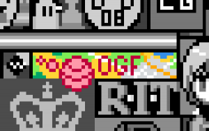
[[File:OpenGeofiction logo highlighted.png|thumb|none|[https://www.reddit.com/r/place/?cx=1088&cy=205&px=56&ts=1648973807221 OpenGeofiction logo on r/place]]] | |||
=== Navenna flag === | === Navenna Flag === | ||
{{SeeAlso| [[Navenna Flag]]}} | |||
<!---Some Art was a piece of artwork that some community made depicting a thing.---> | |||
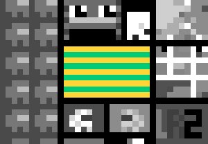
[[File:Navenna flag highlighted.png|thumb|none|[https://www.reddit.com/r/place/?cx=1091&cy=1308&px=52&ts=1649029487221 Navenna flag on r/place]]] | |||
== Alliance == | == Alliance == | ||
[[Alliance of New York Institutions]] | [[Alliance of New York Institutions]] | ||
[[File:ANYI Most Complete.JPG|thumb|none|Alliance of New York Institutions]] | |||
== History == | == History == | ||
[[Category:Communities]] | [[Category:Communities]] | ||
Latest revision as of 10:33, 16 April 2022
| OpenGeofiction | |
| Name | OpenGeofiction |
| AKA | OGF |
| Description | OpenGeofiction is a collaborative platform for creating fictional maps based on OpenStreetMap |
| Subreddit | opengeofiction |
| Discord | OGFC (private) |
| Website | opengeofiction.net |
| @opengeofiction | |
| Artwork | OpenGeofiction Logo, Navenna Flag |
OpenGeofiction, shortly OGF, is a collaborative platform for creating fictional maps based on OpenStreetMap.
The project includes a large map (identical to the real-life Earth, both by nature and size) which users can edit and create a numerous amount of things.
The map is divided into territories which primarily include countries (or states/provinces in rare instances). A new user is allowed to edit in a territory nicknamed a blue territory. When they create a sufficient amount of mapping, they may request a territory of their own, or join a collaborative territory with other users part of it.
r/place 2022[edit]
Artwork[edit]
OpenGeofiction Logo[edit]
- See also: [[ OpenGeofiction Logo]]
[edit]
- See also: [[ Navenna Flag]]
Alliance[edit]
Alliance of New York Institutions


