| Dutch Caribbean Islands | |
| Name | Dutch Caribbean Islands |
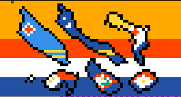
| Description | The (rough) shape and flag of the Dutch Caribbean Islands. |
| Location | 851, 18 |
| Creator | r/placeNL |
The Dutch Caribbean Islands was a drawing on the 2022 canvas on top of the Dutch Flag created by r/placeNL
The drawing depicts 6 islands owned by the Kingdom of the Netherlands located in the Caribbean. The islands are (In order of left to right in the picture): Aruba, Curaçao, Bonaire, Sint Maarten, Sint Eustatius and Saba.
It's important to note that while the entire island of Sint Maarten was drawn on the canvas. The Kingdom of the Netherlands merely owns half. The other part of the island is owned by France. The choice to still draw the entire island was made because half an island would look weird. And the flag would be way harder to draw.
